|
| |
Trimble GPS Map 110
Moving Map for Aviation

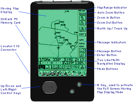
| Map 110 Locator
| Navigation Information | Waypoint
|
Nearest Waypoint | Flight Plan
| Calculations | Database
|
Trimble Sextant Button | Zoom Features
| Other Features | Specifications
|
 | Trimble's large display area and unique updatable touch-screen
control system make the yoke-mounted GPS MAP 110 the superior
choice for inflight GPS Navigation.
|
| Display |
| Better clarity than any GA panel-mounted map or hand-held
unit on the market
Over 12 times the resolution of its most popular competitor.
Trimble's large display features 320 x 256 pixels
Over 12 square inches of display area
|
| This superior resolution equates to superior readability.
Airspace boundaries and airport names are easy to read.
The map shows up to 500 miles at a glance.
|
| Back to Index
|To Top |
| Map Features |
| Zoom Features: |
| Zoom Ranges from 1 nautical mile to 400 nautical miles
-- Corresponds to 500nm full screen top to bottom. (This is how
our competition measures.)
Auto Zoom shows both the aircraft and the next waypoint automatically
zooming in as you near the waypoint.
|
| North or track up display
Automatic screen de-clutter of information displayed
User customizable -- The user can selectively enable/disable based
upon zoom range: |
| Airports and Identifiers or
Only airports with runways longer than specified length
VORs and Identifiers, NDBs and Identifiers
Intersections and Identifiers
Class B and C Airspace, Controlled Airspaces and Names |
| All Screen Map Display |
| With single button push can turn whole display into a map.
|
| Back to Index
|To Top |
| Database: |
| "Direct To" key sets destination to anywhere
in the database
Database Effective Date
Database Search Regions: |
| Over 50 search regions allowing the user to tailor what information
may be retrieved from the database. By only selecting regions
that the user flies in, data is retrieved more quickly and operator
errors are reduced. |
| Airports |
| Identifier
City Name and State
Facility Name
Radio Frequencies: ATIS, Approach, Tower, Ground, CTAF, Unicom
Field Elevation
Beacon at Field
Lighting Available
IFR Approach available
100LL (Low Lead) Fuel Available
All Runways Including: |
| Runway Diagrams
Runway Number
Length
Width
Surface Type
Traffic Direction |
| Latitude and Longitude |
| VORs and NDBs
|
| Identifier
City Name and State
Facility Name
Radio Frequency
Morse Code
Latitude and Longitude |
| Intersections |
| Identifier
Geographical Region
Latitude and Longitude |
| Waypoints: |
| User Waypoints |
| Up to 250 user waypoints can be created as:
Latitude and Longitude
Present Position
Another Waypoint Plus Range and Bearing
One Button Save of up to 10 additional Waypoints
Waypoints may be copied and edited. |
| Nearest Waypoint: |
| Nearest 30 Airports, VORs, NDBs, Intersections and User Waypoints
|
| Back to Index
|To Top |
| Vertical Navigation Computer |
| Signals begin and end of a descent or climb
Shows target altitude during the descent or climb |
| Flight Planner Calculator
|
| Computes range, speed and times |
| Fuel Computer
|
| Estimates fuel required to reach destination |
| Fuel Timer
|
| Real time estimates of: |
| Fuel, Range and Time Remaining
Fuel, Range and Time Reserves at Arrival
Total Fuel Used |
| Pressure and Density Altitude Calculators
True Airspeed Computation
Winds Aloft Computer
Cross Winds for Landing Calculator
|
| Back to Index
|To Top |
| Primary Navigation Display Shows:
|
| Bearing, Distance and Time to Destination
Course Deviation Indicator
Ground Track and Ground Speed |
| Additional Displays For:
|
| Current Latitude, Longitude and GPS Altitude
Even/Odd Altitude Reminder
Minimum Safe Altitude and Minimum Enroute Safe Altitude
Estimated Time Enroute and Estimate Time of Arrival
Desired Track, Current Track and Cross Track Error
Range, Bearing and Distance to Second Waypoint
|
| Back to Index
|To Top |
| Date, Local and Zulu Time
GPS Receiver Battery Life Gauge
GPS Signal Status Including Displays of Satellite Positions and
Signal Levels
Course Deviation Indicator (CDI) Scale Adjustment
Automatic or Manual Magnetic Variation Settings
ETA in Local or Zulu Time
Home Demonstration Mode
|
| Back to Index
|To Top |
| Specifications:
|
| General
| Performance | Environmental
| Technical | Physical
| Remarks
|
| General:
|
| Operates on AA Batteries (included) or from 9-32 volts from
aircraft power (with optional accessories). Database and features
are on the UniCard (TM), a standard-format computer PC memory
card (PCMCIA Type 2); initial database is for U.S. 48 states only;
greater geographic regions will become available with updates.
Updates are available via subscription or one time purchases.
The GPS MAP 110 system includes: the Casio Z-7000 personal computer,
Locator GPS antenna, Yoke Mount, screen light, and UniCard (TM)
PC memory card.
|
| GPS Performance Characteristics:
|
| General: Tracks up to 8 satellites
Update Rate: 1 second (typical)
Time to first fix: Warm: 30 Seconds
Cold: Less than two minutes (typical)
Re-acquisition: Less than 2 seconds
Accuracy* (typical): Position: 15 meters (49 feet) RMS
Velocity: .1 m/s (0.1 knots) RMS
Dynamic Tracking: Velocity: 0-514 meters/second
(999 knots)
Acceleration: 4g
|
| Environmental Specifications (GPS
Receiver):
|
| Operating temp: -10°C to +60°C (-14°F to 140°F)
Storage temp: -20°C to +70°C (-4°F to 158°F)
Altitude: -400m to + 18,000m (45,720 ft)
Humidity: up to 95% non-condensing.
|
| Technical Specifications:
|
| Power consumption: |
| Locator GPS Antenna/Receiver: 4 AA batteries,
Typical 8-hour Battery Life or
Operates on 9-32 volts from aircraft power (optional ). |
| Casio Z-7000 PDA: |
| 3 AA batteries, Typical 25-50 hour Battery Life.
Serial Interface: RS-232
Antenna type: Built in low-profile microstrip patch for glare
shield mounting
|
| Physical Characteristics: |
| Size: |
| Casio Z-7000 PDA: Display measures 1"h x 4.25" w
x 6.941"l
GPS Antenna/Receiver measures 1.67"h x 3.15"w x 5"l |
| Weight: |
| Casio Z-7000 PDA: Display weighs 15.2 oz. (o.43 kg)
GPS Antenna/Receiver Antenna weighs 12 oz. (0.34 kg) |
| Display: |
| Casio Z-7000 PDA: 3.2" x 3.9"h, 256 x 320 pixels |
| Specifications are subject to change
without notice.
One year warranty.
* All GPS receivers are subject to degradation of position and
velocity accuracy under Department of Defense imposed S/A (Selective
Availability). Position may be degraded up to 100 meters 2D RMS.
Trimble maintains a FaxBack database of information on GPS products
and applications.
To learn how to use FaxBack or access the FaxBack database, please
call 1-408-481-7704.
Back to Index
|To Top |
Content Material: Glenn Steiner
Design by DRIVE, Inc. |